


アクティブ・レンジャー日記
Aso Nakadake New trekking routes newly opened on April 28th, 2021!
2021年05月10日Hello, I'm Yuka from Aso-Kuju National Park Office.
Mt. Aso Nakadake new trekking routes opened on April 28th, 2021 and the opening ceremony was held at Mt. Aso Visitor Center (Aso Volcano Museum).

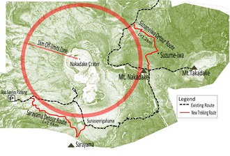
Mt. Nakadake is one of the few volcanos in the world where observers can directly look inside the crater, the mountain attracts a constant stream of tourists. On the other hand, when there are restrictions on Mt. Nakadake crater, some trekking routes to Mt. Nakadake and Mt. Takadake are not accessible. Since we now have 2 new trekking routes to Mt. Nakadake and Mt. Takadake, it'll be accessible anytime even under volcanic alert level 2. ※Volcanic alert level 2 means the area within 1km from the crater is off-limits.
Important note: Mt. Nakadake crater can be temporarily closed depending on the volcanic activity. If the volcanic alert level goes up to level 3 and above, you cannot approach the volcano and access to Mt. Nakadake and Takadake will be prohibited.
■Suzumeiwa detour route
On this trekking route, there is a valley called "Suzume no Jōdo" and the rocks nearby look like Suzume (Sparrows). That is how we named this route.
There are rope fences in dangerous areas for you to safely enjoy your walk.

▲Suzumeiwa (Do they look like 2 sparrows?)

▲Rope fences
■Sarayama detour route
Through this route, you will be passing the ridge of Sarayama side. You'll be able to enjoy the whole view of Sunasenri-ga-hama and even see Miyama kirishima (azaleas) bloom during the season.

▲Starting point for detour route

▲The view from Sarayama detour route
Enjoy trekking Mt. Aso following the restrictions.
Please check the latest restriction information here.
http://www.aso.ne.jp/~volcano/
The latest trekking information on Mt. Aso is here.
http://www.city.aso.kumamoto.jp/tourism/spot/mountain-climbing/